The dissertation project researches singular aspects and overall strategies of spatial organization in and around Petra, Jordan. The chronological frame ranges from the Iron Age until Late Antiquity. However, the main focus lies within Nabataean-Roman times.
Research
The project aimed at delivering new and innovative insights into the Petra hinterland and its relationship to the city itself. In addition to general thoughts on the military and non-military control of Petra´s surrounding, the project also conducted an archaeological documentation of built structures in order to comprehend the physical control and use of the landscape.
Preliminary Results
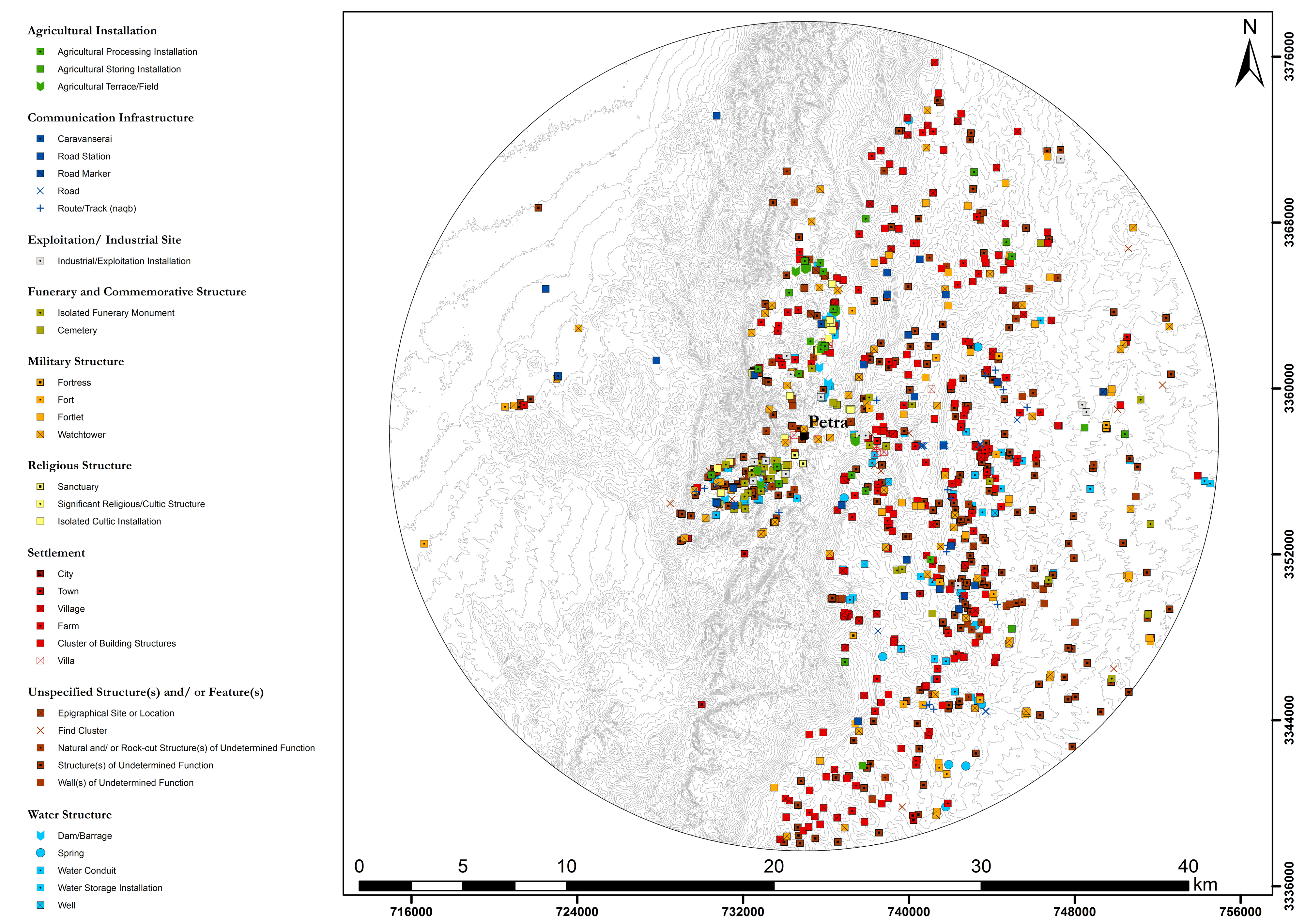
Fig. 1 :Site distribution map of archaeological sites evidenced for the 1st century AD in the Petraean hinterland (20km radius around Petra) | Author: W. M. Kennedy (click to enlarge)
So far the project has successfully processed and reevaluated approx. 1800 previously surveyed archaeological sites within the Petra area. However, intensive fieldwork was also conducted in order to clarify sites on the ground and to add new data to the existing archaeological dataset of the Petraean hinterland (fig. 1). Furthermore, in order to research the landscape organization of rural Petra over time, the in part greatly differing chronological classification systems of the archaeological base data had to be synchronized. Otherwise the chronological inconsistencies inherent to the base data would not allow any diachronic analysis. Therefore, a methodology was developed in order to quantify these inconsistencies and to make them transparent for further research. This resulted in dating probability graphs for each evidenced cultural period in the study area based on the chronological information provided by the base data (fig. 2).
Further results of the conducted fieldwork included the extensive walking and mapping of ancient caravan routes in order to further clarify the ancient communication networks of the study area. A particular focus was laid on the so called naqb that connected Petra with its western hinterland towards the Wadi ‘Arabah and eventually also the Negev desert since these have been of only limited scholarly focus so far.
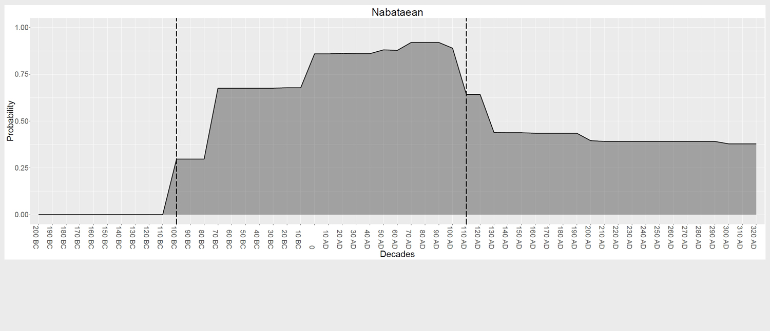
Fig. 2: Dating probability graph for the Nabataean Period as stated by the original reports. The dashed lines represent the limits of the more realistic classification of the period | Author: W. M. Kennedy | Click to enlarge
Finally, while extensively exploring the Petraean hinterland first-hand, the significance of natural landscape factors for the rural organization and spatial strategies in the hinterland of Petra was recognized. Without being too environmentally deterministic, Petra’s extreme environmental conditions greatly impacted the structural and social exploitation of its cultural landscape. Not only did topographical and geological conditions influence the course of major caravan routes, it may be argued that the extreme natural landscape settings also inspired both an architectural manifestation and representation (i.e. a more sedentary architecture) in the landscape, as well as more mobile architectural designs where only a minimum of structural installations were required in order to fulfil functional purposes (fig. 3).
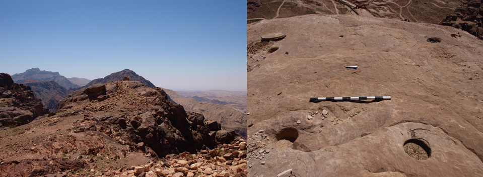
Fig. 3 Left: A small hilltop sanctuary at Ras Slaysil, prominently displayed at the edge of a steep cliff before the dramatic drop towards the Wadi ‘Arabah. Right: Presumed post-holes for tent-like installations on top of Jabal Umm Zeythuna in Petra | Author: W. M. Kennedy
These observations highly reflect the dual character of Nabataean culture in general. While the increasing monumentalization of urban Petra mirrors a seemingly sedentary culture, the archaeological evidence in the hinterland of Petra suggests both a sedentary lifestyle as well a culture that still maintained its pastoralist and (semi-)nomadic roots. It should be emphasized, however, that it is not suggested that these different lifestyles were antagonistic, but rather complementary to each other, both being equally important for understanding Nabataean culture as a whole.
This dissertation project was written within the framework of the program “Landscape Archaeology and Architecture” (LAA) of the Berlin Graduate School of Ancient Studies (BerGSAS) and was successfully completed in 2018.
Related Publications
Will M. Kennedy and Felix Hahn, “Quantifying Chronological Inconsistencies of Archaeological Sites in the Petra Area”, in: eTopoi. Journal for Ancient Studies, Volume 6 (2017), 64–106
Will M. Kennedy, “Ein Versuch einer Higuchi-Viewshed-Analyse am Beispiel eines Wachturms auf der Umm al-Biyara in Petra, Jordanien”, in: Undine Lieberwirth and Irmela Herzog (Eds.), 3D-Anwendungen in der Archäologie. Computeranwendungen und quantitative Methoden in der Archäologie. Workshop der AG CAA und des Exzellenzclusters Topoi 2013, Berlin: Edition Topoi, 2016, 157–179