The Tabula Peutingeriana (TP), Peutinger Map, is one of the most impressive surviving medieval manuscripts. Its significance has been highlighted by being placed on the UNESCO memory of the World Register. The Map – a parchment roll of 36 cm high and 7 meters long – depicts nearly the whole of the known ‘Ancient World’ from Iberia to India.
Research
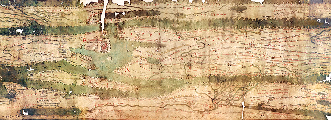
Tabula Peutingeriana, detail, ink on vellum, 660 x 37 cm | Vienna, Austria, 12th / 13th century | Österreichische Nationalbibliothek.
The starting hypothesis of the research carried out by Michael Rathmann and Monika Schuol was that the TP was based on a chorographical map of Eratosthenes (3rd century BC), which was expanded with diverse information during its process of reception until its ultimate revision in Late Antiquity. Since the TP, in each step of reworking, was never completely modernised, traces of the older version still remained.
Michael Rathmann investigated the representation of Italy on the TP in order to work out the different time levelsbetween the prototype map of the 3rd century BC and its late antique ultimate revision. He pointed out that some names reminiscent of the time of Augustus show up in close vicinity to other entries related to Diocletian’s provincial reorganization, whereas other toponyms are well known from Late Republican days. The coexistence of the towns Stabiae and Pompei, destroyed by Mount Vesuvius in AD 79, and Aquileia, represented as a late antique residential city with a particularly large town vignette, is another case of entries from two different chronological phases. The Church of Saint Peter depicted near Rome represents the youngest temporal stage of the TP. Michael Rathmann sheds new light on the representation of Italy on the TP and, more generally, on the broader field of ancient cartography.
Monika Schuol devoted her research to the vast geographical space represented east of the Euphrates This was the first time that the eastern part of the ecumene, especially the eye-catching depiction of a giant hydrographic net including the rivers Ganges, Euphrates and Tigris with Babylonia at its centre, has been approached and systematically investigated.Using a new explanatory model she defined this irritating geographic information as depiction of the Rivers of Paradise (the Nile is missing) flowing out of Eden as it is described in the biblical account of creation (Gen 2, 4-3, 24). Examining areas of Tabula – so far underexplored by the cartographic point of view, such as Egypt, Ethiopia, and the southern part of the ecumene –she has clearly shown how intense was the influence of the Judeo-Christian and pagan sources in the map.
In 2015 Monika Schuol delivered two papers on the eastern segments of the Peutinger Map.Preliminary results are available in: Monika Schuol, “Indien und die großen Flüsse auf der Tabula Peutingeriana: die östliche Oikumene zwischen paganer und christlicher Kartographie”, in: Orbis Terrarum, 14 (2017), 92–155
In September 2015 the conference “Kartographie in der Antike und in den Kulturen des Vorderen Orients” brought together a wide range of experts from different disciplines, and countries. In a friendly and stimulating atmosphere, key aspects of the TP as well as key concepts of cartographical sources of non-European origin has been discussed. Another international conference, “Die Tabula Peutingeriana und die antike Kartographie” (further information on H/Soz/Kult) provided a forum for critical and fruitful debate.
Results
Michael Rathmann has taken a first step towards further study with the new facsimile reproduction ( “Tabula Peutingeriana Die einzige Weltkarte aus der Antike”, Darmstadt 2017). This book is already in its second edition. Monika Schuol was invited to the International Medieval Conference (3.-6.7.2017, Leeds) to present a paper on the TP (“The Peutinger Map – pagan topography within the Christian geography?”).
In addition, the project succeeded in raising funds to continue the work on the eastern segments and Italy: The project “Kommentar zur Tabula Peutingeriana”, funded by the German Research Foundation (DFG), started on October 1st, 2017. The project team consists of Michael Rathmann, Monika Schuol and Silke Diederich.